Location Types
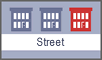
Street Address
STREET ADDRESS: An
address consists of a street number, a street name, and a quadrant (NE, NW, SE,
SW). The address number and street name are required. Every address in the MAR
as also been assigned an AID# (Address Identification Number) which can be used
to retrieve additional data about that address.
Example: 441 4th ST NW
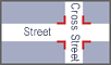
Intersection
INTERSECTION: An
Intersection consists of two streets
Example: 14th ST NW and Pennsylvania Avenue NW, or 14th
ST NW & Pennsylvania Avenue NW, or 16th ST NW over Military RD NW, or
Military RD NW under 16th ST NW, or North Capitol Street NE Northbound and ramp from Irving Street NE Eastbound
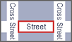
Block
BLOCK: A
block consists of a street and any other cross streets.
Example: 4th ST NW from D Street NW to E
Street NW or 400 Block of 4th St NW

Place Name
PLACE NAME: A
place name consists of common place names and public/institutional building
names.
Example: "White House" or "Dupont Circle" or "Wilson
Building" or "Wilson High School" or "Woodrow Wilson House"